Saturday, January 1, 2011

A New Trail in the Middle Fork?

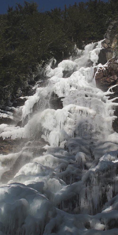
Many of us have followed the boot path up to Kamikaze Falls on the South Slope of Mt Teneriffe but DNR has consistently posted signs saying you shouldn't go there (and we all listen, right?). But now the DNR has constructed a nice trail to the falls and it is well worth it.

Park at the school bus turnaround then follow the road. At about 1.2 miles there is an obvious side road, you will see the trail as you start up that road. Just follow it to the falls. (and just when I thought DNR was run by Darth Vader they go and do something cool like this. OK, another chance).

Can you follow this to the top of Teneriffe? Yes, you can but don't count on it being easy. This is the old Mailbox Peak trail times two for steep and not maintained. At about 2,800 feet is the toughest part, a little scramble up some rocks which is easy when dry, a bit scary with ice. But who can complain about something new to try with 360 degrees of beautiful view and about .1% of the crowd on Mt. Si.

Now DNR just needs to construct a parking lot!

Saturday, December 4, 2010

Middle Fork Road is Snowy but Open

Went up the Middle Fork road today (Dec 4th). The road is open (it seems to have been plowed to just past the Taylor River bridge). If you get off the plowed portion it is pretty tough (10-14 inches snow over ice). Cars can make it to the just past the Taylor River bridge (the road is still gated where you turn right to go up to Dingford) but there is not much room to park. Several cars parked on the road and hard to get around.

The walking is tough right now in the snow, you punch through, but worth it as always on a sunny day.

Sunday, July 25, 2010

Something New


Without a documentary to film I was running out of excuses to go out into the woods. I also learned two things about the US Forest Service while filming Dreams in the Wilderness. First, they really care about the forest and are tasked with an impossible network of conflicting interests. Second, they are terribly understaffed. Can't help with the first but thought I could help with the second so I enlisted in the Volunteer Wilderness Ranger Program.

Turns out this is a pretty cool program and one of the good things the US Government does. I never realized that almost all of the backcountry rangers you run into are volunteers. It is also a great way to get experienced people out into the wilderness in an official capacity helping to preserve and protect it.

Two "thumbs up" to the USFS!

Thursday, May 6, 2010

Wow! A Full House


Last Sunday our film on the Middle Fork Valley, Dreams in the Wilderness: stories from the Middle Fork premiered at the North Bend Theater to a packed house of over 300 people. Zach and I were so proud to show the film and overwhelmed by the response. We just want to thank everyone who came out to watch.

Cindy, owner of the North Bend Theater, not only let everyone in for free but also fixed up Blu-Ray so we could show the full capability of our HD film. Then, so many of you bought books and videos that we made over $350 for the Snoqualmie Historical Society.

If you missed the film, head to the website and get the DVD. The best place to buy it now is at the Snoqualmie Valley Historical Museum in North Bend.


Saturday, April 24, 2010

Great Old Growth


Sometimes it's great to just take a picture. I saw this tree while up on Martin Creek with Cathy McDonald, a freelance journalist for the Seattle Times. I didn't have time to get the right angle, so I went back the next week. Now I have the angle, but need blue skies. That will be another trip.

BTW: Check out Cathy's article on the hike: Northwest Weekend article

The New Pratt Trail

The new Pratt Valley trail, which will connect from the Wilderness Gateway Bridge at the Middle Fork Trailhead, is going in. The WTA has sign ups to help if you would like to contribute to this work:


Saturday, April 10, 2010

The Road is Really Open (ignore the signs)


It really puzzles me why these two signs are on the Middle Fork Road because it is open for 12.5 miles (to the Taylor River Trail, the road to Dingford is gated). Here is my theory:

Yellow Sign: This is the county and is referring to the upper road that is washed out. The lower road is actually the Lake Dorothy Road.

White Sign: The distance refers to the distance to the gate at the USFS boundary that was put there when they were doing work on the Taylor River bridge (that gate is most definitely open). My guess is that this sign was put up by DNR (they own the land at Mailbox Peak) and either just haven't taken it down or would like to think the road is closed (so that all of Washington will only use the Mt. Si trail).